Revista Cartográfica 106 | enero-junio 2023 | Artículos
ISSN (impresa) 0080-2085 | ISSN (en línea) 2663-3981
DOI: https://doi.org/10.35424/rcarto.i106.2667
Este es un artículo de acceso abierto bajo la licencia CC BY-NC-SA 4.0
Analyzing Segregation of Informal Residents in Latin American Cities’ Periphery Using Remote Sensing
Analizando la segregación de los asentamientos informales en la periferia de las ciudades latinoamericanas usando imágenes satelitales
Sonia Morales1
Recibido 19 de septiembre de 2022; aceptado 21 de octubre de 2022
Abstract
The urban pattern has changed significantly in Latin American cities over the last decades. Since the 1980s, urban policies have increased the periphery land value, promoting suburbanization that restricted spaces for informal settlers. The study used Landsat imagery to analyze if urban pattern changes in Bogota, Colombia and Sao Paulo, Brazil forced informal settlements to move closer to environmental risk areas or areas with limited mobility. This research used a stratified supervised classification to locate formal and informal developments in 2000 and 2018, followed by multiple criteria evaluation to categorize environmental risk and mobility in the study area. The results revealed that segregation in the periphery of cities is not a generalized pattern in the city periphery but a localized phenomenon encouraged by urban policies.
Key words: remote sensing, segregation, informal settlements, city's periphery.
Resumen
En Latinoamérica, los patrones de crecimiento urbano han cambiado significativamente en la última década. Desde los años ochenta, las políticas urbanas han hecho que el valor del suelo la periferia de las ciudades crezca restringiendo el espacio disponible para asentamientos informales. Esta investigación usó imágenes satelitales Landsat para analizar los cambios urbanos en Bogotá, Colombia y Sao Paulo, Brasil que forzaron a habitantes informales de la ciudad a desplazarse cerca a zonas de riesgo o áreas con movilidad limitada. El estudio utilizó una clasificación supervisada y estratificada para localizar desarrollos formales e informales seguido por una evaluación de criterio múltiple para categorizar riesgo ambiental y movilidad en el área de estudio. El estudio encontró que la segregación en la periferia de las ciudades no es generalizada, es un fenómeno localizado incentivado por las políticas urbanas.
Palabras clave: imágenes satelitales, segregación, asentamientos informales, periferia urbana.
1. Introduction
Historically, poor and informal residents settled closer to the urban periphery, in a hierarchical structure in Latin American cities. Land cost is a main factor. The lack of infrastructure and poor public services in the city fringe make the land cheaper, and poor residents take those locations due to the low cost. However, the "best location" in Latin American cities has changed significantly in the last decades. Neoliberal policies, implemented in the '80s, have increased the city's periphery land value, promoting a formal suburban development. New developments for high and middle-class residents still occupied the best locations but are now on the periphery of cities. The social structure is forcing poor residents to relocate to disadvantaged sites.
The research evaluates how high- and middle-class residential areas affected poor residents in the periphery of Bogota, Colombia, and Sao Paulo, Brazil due to urban policies adopted since 2000. The project uses Landsat images and GIS data to locate informal settlements and identify hazardous places. The aim is to visualize the segregation patterns of informal residents from the year 2000 to the year 2018.
1.1 Urban Patterns in Latin American Cities Changed by Urban Regulations
In the twenty-first century, neoliberal urban policies, adopted in Latin American cities, introduced zoning boundaries and limited lot by lot city sprawl outside the administrative border. However, those zoning regulations did not limit the population settled illegally in cities. In 2017, the UN Economic Commission for America Latina (CEPAL) informed that at least 30% of the population of Latin American largest cities live in informal settlements (CEPAL, 2018).
In general, the condition of informal settlements has been upgrading over time in Latin American cities (Rocco et al., 2019). Nevertheless, some characteristics are the same in informal settlements over time, such as a disorganized plot, inadequate transportation infrastructure, and deficiencies in sewage and electricity due to an unplanned development (Hardoy & Pandiella, 2009). The vulnerability of poor populations living in informal settlements has become the central social issue for national governments in Latin America in the last two decades (Allen et al., 2017).
At the national level, Latin American countries created policies, national entities, and planning strategies to manage environmental risk to solve this problem in the late 1990s. At the local level, measures focused on preventing disaster and reducing populations' vulnerability by relocating people to new public housing projects. For example, people living in informal settlements established in high-risk zones were relocated to housing projects, which reduced in numbers the amount of poor people's vulnerability but did not fulfill the social needs of those populations (Hardoy & Pandiella, 2009).
The new market was attractive to private companies who started to suburbanize the city's fringe at the beginning of the century. The purpose of public housing changed and attracted the middle-class, high-class population. The new urban pattern affected illegal residents of the urban fringe. Real estate developers built gated condominiums in former shanty areas (Lopez -Morales et al., 2016). The unequal growth of cities’ fringe has an origin in the neoliberal land-use policies incorporated at the beginning of the century. From that moment, the urban fringe developed into an urban structure sprawled but fragmented, and highly segregated, creating a spatial class configuration that affects principally poor residents (Aguilar et al., 2003; Castro-Correa et al., 2015; Gilbert, 1998; Inostroza et al., 2010; Inostroza & Tabbita, 2016).
The new regulations created physical barriers to settling in cities. At the same time, they allowed private big housing projects to surpass urban city limits to accommodate the periphery's social housing demand and reduce urbanization public costs. For instance, Partial Plans in Colombia and the ZEIS program in Brazil exchanged the cost of urbanization for a high-profit margin of new housing in the periphery with private investors. Several researches proved that those private new projects did not improve the living conditions of the marginalized populations (Codina, 2005; Klaufus, 2013). The cost to supply public services in the expansion area was not assumed by the State but by private investors that only supplied their developments. Only the more profitable parts of partial plans were built, and the plan's public services provision was sometimes not executed (Montaña & Borrero, 2015). Consequently, the public transportation system, operated by private companies, did not see profit in routes without proper streets and public adequations.
The public service shortage and minimum transportation access affected principally illegal settlers in the city fringe. One of the reasons is that unplanned houses, informally developed, did not have paved roads or adequate transportation infrastructures, such as sidewalks, bus stops, or feeder routes in illegal neighborhoods (Jaitman, 2015; Yañez-Pagans et al., 2019). Cities invest in public infrastructure mainly in the principal streets or highways (Angotti, 2013), and transportation networks in the periphery of cities are incorporated after urban development is consolidated.
The mobility issues of poor residents in Bogota, Colombia, and Sao Paulo, Brazil, have been studied before. Bogota has an internationally recognized Bus Rapid Transit (BRT) system, 'Transmilenio,' that improved commute, quality, and security. However, several studies have found that the system is highly exclusionary. Bassett and Marpillero-Colomina (2013) argued that 'Transmilenio' is a gentrifying agent that displaces poor residents from its main stations. Moreno & Miralles-Guasch (2017) indicated that the periphery's service is precarious, 'feeder buses' are limited in some areas. Guzman et al. (2017) found that the system is highly unequal. The rationale for locating bus stops and stations depends on the amenities nearby and not serving people who actually need the service.
In Sao Paulo, Brazil, the transportation infrastructure has similar problems. Favelas in Brazil have limited access to public transportation systems due to the overcrowded conditions of neighborhoods. Sao Paulo BRT lines go mainly from the periphery to the city center, not tangentially connecting neighborhoods (Tomasiello et al., 2019). Studies revealed that the BRT system is inefficient, buses are overcrowded, and routes have unreliable schedules (Amparo Alves, 2014; Hyman, 2018). Weak mobility is one of the main problems of people living in informal settlements on the periphery of Latin American cities.
The environmental conditions such as steep slopes, wetlands and rivers within the city, and rainy seasons limit land for settlement in Latin America. Several researchers have studied the vulnerability of informal settlements in high environmental risk areas. Wenzel et al. (2007) observed that informal settlements are exposed to environmental hazards due to the low quality of construction and the high density of settlements. Hardoy & Pandiella (2009) found that people living on the fringe of Latin American cities are exposed to more environmental hazards than people living in the center of cities due to their low access to disaster assistance. In the same context, Allen et al. (2017) discovered that informal settlements experience higher ecological risk because the poor inhabitants are marginalized in "risk traps" with consecutive small-scale disasters, highly localized and with difficult access. For instance, Informal settlements in Bogota are typically located in the "Cerros," steep slopes situated in the south and east (Maceratini, 2011); Even though the sector consolidated years ago, the access is through small unpaved roads inaccessible to cars, people have to walk an average of 30 minutes to bus stops (Moreno and Miralles-Guasch, 2017). The complex topography and unplanned origin of informal settlements restrict their urban structure and limit the growth connected to the city.
Favelas in Sao Paulo have a similar problem with the transportation network. However, the primary concern of informal settlements in Sao Paulo is that they are located in flooding zones. The environmentally risky location created several problems. On the one hand, public regulations prohibit sewerage installation in flooding locations (Budds & Teixeira, 2005). On the other hand, informal settlements are located on land reserved for forests that cannot be regularized (Silva & Ceneviva, 1996). Additionally, the sprawl of the Sao Paulo Metropolitan Area involves 39 municipalities making it challenging to consolidate a unified policy for informal developments. Finally, the political division of each city creates barriers to locating and preventing environmental risk outside their political boundary.
In summary, neoliberal policies implemented in many Latin American cities increased spatial segregation in different ways. First, the economic structure of cities increased class inequalities geographically, with a system that mainly benefited the wealthier population. Second, the deregulation of the land market facilitated peripheral suburbanization and created a social problem for poor inhabitants. Finally, service infrastructure in the periphery of cities was constructed unequally, serving principally high and middle socio-economic classes. Therefore, urban policies implemented in cities since the 2000s have focused on economic interest over social justice. The change in the public policy creates a time frame to research the segregation of informal settlements in Latin American cities.
1.2 Remote Sensing Images to Analyze Urban Patterns
In Latin America, urban sprawl of cities has been studied mainly through census information (Aguilar et al., 2003; Inostroza et al., 2010; Inostroza, 2016; Inostroza & Tábbita, 2016; Rojas et al., 2013), which focused on the change of population density within the administrative boundary. However, it creates a normative gap in locating informal settlements outside the urban boundary.
The use of satellite images to map slums is widely used. Kohli et al. (2012) used very high resolution (VHR) images to create a rapid inventory of the location and physical composition of slums. They were able to explain patterns over time and space using remote sensor data; however, they found that visual interpretation methods required local expertise to produce reliable results. Mahabir et al. (2018) indicated that VHR images can capture information in real-time compared with traditional survey methods which are labor-intensive, time-consuming, and may require significant financial support depending on the study area size.
In Latin America, the use of VHR images for mapping informal settlements is scarce. It needs several images to provide city-wide coverage, which increases the cost of the study. The VHR images have a temporal limitation; satellites such as Worldview-1 that cover the area were launched in 2007 which means that VHR images before that date are not available to conduct a temporal analysis of informal settlements' urban growth.
Based on the literature review, remote sensor data are appropriate to measure informal settlements in a city scale. This research explores an inexpensive way to map informal settlements in Latin American cities using moderate resolution images from LANDSAT enhanced with pan-sharpening. The methodology is particularly relevant to raise the interest of studying poverty and informal housing in Latin America beyond public institutions. In addition, the research explores the connection between new developments and informal settlements and how urban regulations may increase Latin American cities' inequality. Identifying this problem will help public institutions to reframe urban public policies towards better solutions for informality other than displacement.
This study aims to contribute to a better understanding of the spatial segregation patterns in Latin American cities. The research evaluates the growing high and middle-class residential areas in the periphery affecting informal settlements due to urban policies adopted after 2000. Furthermore, the study identified how mobility and exposure to environmental hazards affected informal settlements over time.
2. Methodology
2.1 Area of study
The research analyzed the change of urban patterns in two Latin American cities; Bogota, Colombia, from 2002 to 2018, and Sao Paulo, Brazil, from 2000 to 2017 (Figure 1). Both municipalities have similarities in topography, economic relevance in their country, and comparable urban growth patterns. Also, they have a concentric and compact city center and a dispersed pattern in the periphery. Additionally, they incorporated the Bus Rapid Transit (BRT) system and introduced neoliberal Strategic Master Plans at the beginning of the 21st century. Finally, both cities' periphery has hazardous environmental conditions such as steep slopes and areas exposed to floods.
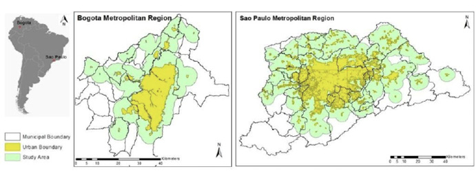
Figure 1. Study area in Bogota Metropolitan Region and the Sao Paulo Metropolitan Region.
The study aims to identify changes in the area beyond the denominated urban expansion area. The main reason for selecting the margin outside the urban area is that cities prohibit urban construction outside the border, making informal settlements more likely to exist. Therefore, the study applied a four-kilometer buffer from the urban administrative boundary to identify the expansion area used for this study. Additionally, the research excluded towns smaller than 300,000 square meters that are not representative of the study scale.
2.2 Methods
The procedure of this study is illustrated by the flowchart shown in Figure 2. The methodology included three sections: an image classification of formal and informal settlements in the study area, rank environmental risk by population, and rank mobility by population. The first section identified the change in urban patterns for formal and informal developments during the study period. The second section identified if the risk level for each settlement has increased or decreased over time. Finally, the third section identified whether each settlement's mobility has changed overtime.
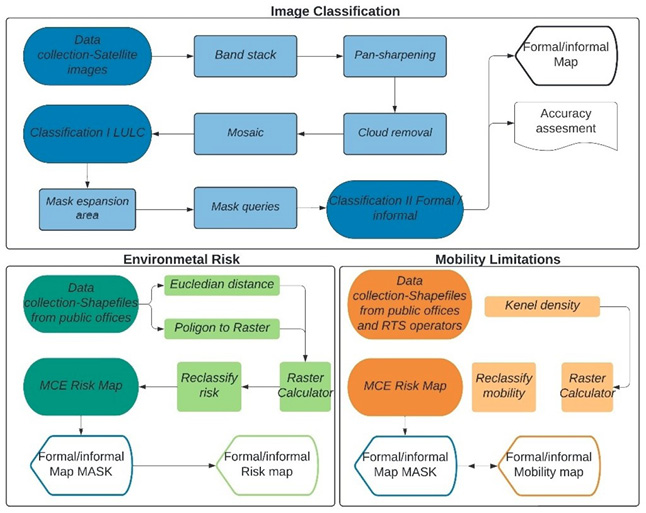
Figure 2. Methodology Flow Chart.
The study's general timeline is from 2000 to 2018, covering the beginning of the implementation of neoliberal urban policies in Latin America. Although cloud cover is an issue in the Andes region, the study used data from adjacent years to get cloud-free mosaics for both cities. Tropical cities are not affected by seasonal changes. For that reason, the study acquired data across seasons to help increase data availability. The image characteristics are described in Table 1.
The image processing was based on a stratified classification process. Initially, a supervised classification using the maximum likelihood algorithm was applied to identify eight land cover types. Once the urban area's land cover classes were extracted, the study applied a second classification to the urban areas to further classify formal and informal settlements. The characteristics of formal development were lots with regular size, square shape, similar roof materials, urban grid pattern, paved streets with sidewalks, light posts, traffic signs, and electric provision. Informal development training sites were characterized by a small street size, no paved, or non-existent sidewalk organic urban structure, irregular plot size, shapes and highs, and roof materials.
Table 1. Characteristics of Landsat data used in this study
Location |
Sensor |
Path/row |
Resolution |
Projection |
Date |
Bogota, Colombia |
Landsat 8 OLI_TIRS |
008/57 |
Multispectral: 30m Panchromatic:15m |
UTM 18N |
2018/12/30 |
Landsat 7 ETM+ |
008/57 |
Multispectral: 30m Panchromatic:15m |
UTM 18N |
2001/01/21 2002/02/25 2002/09/21 |
|
Sao Paulo, Brazil |
Landsat 8 OLI_TIRS |
219/76 219/77 |
Multispectral: 30m Panchromatic:15m |
UTM 23S |
2017/07/26 2017/07/26 |
Landsat 7 ETM+ |
219/76 219/77 |
Multispectral: 30m Panchromatic:15m |
UTM 23S |
2000/04/30 2001/08/30 |
Once formal and informal areas were classified, the study used a raster-based multiple criteria evaluation (MCE) to identify environmental risk areas. Then, they used Euclidean distance to normalize the data. After that, the researchers calculated the number of pixels according to their risk value using landscape metrics to evaluate risk in informal and formal developments. The study used a similar methodology applied Kernel density instead of Euclidean distance, then landscape metrics to evaluate the mobility of informal and formal developments in the study area.
2.3 Accuracy Assessment
The study used an error matrix to assess the accuracy of image classification, using reference data collected from Google Earth's high-resolution images (Table 2). The accuracy assessment was based on stratified random samples. According to each city's location, patch size, and total area, the number of samples increased.
The overall accuracy of all maps varies from 82.9% to 86.7% (Table 2). Although the accuracy assessment showed that informal settlements classification had slightly lower accuracy than formal developments, it is considered adequate for the purpose of this study for comparing the general patterns of informal settlements.
2.4 Environmental risk of informal settlements
The study used a raster-based multiple criteria evaluation (MCE) approach to calculate environmental risks that affect Bogota and Sao Paulo metropolitan regions (Figure 3). This methodology weighted variables such as proximity to rivers, proximity to wetlands, proximity to forest, and slope to identify an overall risk level.
Table 2. Error matrix of accuracy assessment
DATA |
Bogota, 2002 |
Bogota, 2018 |
||||||
Reference data |
Reference data |
|||||||
|
Formal |
Informal |
Total |
User's accuracy |
Formal |
Informal |
Total |
User's accuracy |
Formal |
33 |
2 |
35 |
94.30% |
195 |
20 |
215 |
90.70% |
Informal |
10 |
25 |
35 |
71.40% |
29 |
91 |
120 |
75.80% |
Total DATA |
43 |
27 |
70 |
82.90% |
224 |
111 |
335 |
83.30% |
Producer's accuracy |
76.70% |
92.60% |
|
|
87.10% |
82.00% |
|
|
DATA |
Sao Paulo, 2000 |
Sao Paulo, 2017 |
||||||
Reference data |
Reference data |
|||||||
|
Formal |
Informal |
Total |
User's accuracy |
Formal |
Informal |
Total |
User's accuracy |
Formal |
307 |
3 |
310 |
99.00% |
475 |
25 |
500 |
95.00% |
Informal |
18 |
52 |
70 |
74.30% |
134 |
326 |
460 |
70.90% |
Total DATA |
325 |
55 |
380 |
86.70% |
609 |
351 |
960 |
82.90% |
Producer's accuracy |
94.50% |
94.50% |
|
|
78.00% |
92.90% |
|
|
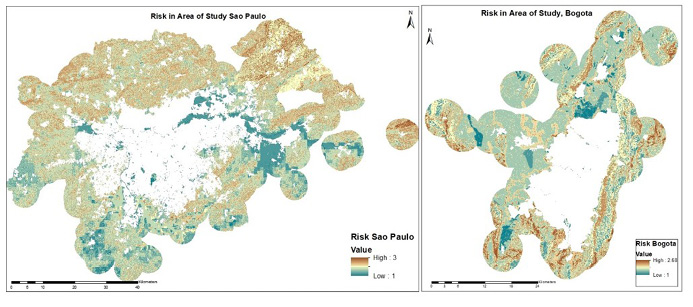
Figure 3. Environmentally risk areas in Bogota and Sao Paulo.
The aim was to produce an assessment risk map for the expansion area to measure the settlements’ hazardous environmental conditions. The study used Euclidean distance to calculate each criterion to determine risk on a relative scale from 1 to 3, in which 1 represents areas with low risk, 2 represents areas with moderate risk, and 3 illustrates areas with high risk.
2.5 Mobility of informal settlements
To measure mobility, this study used data from public transportation systems in each city, including bus routes and stops and main roads connecting metropolitan areas. Both cities have BRT systems, called ‘Transmilenio’ in Bogota and ‘Expresso Tiradentes’ in Sao Paulo. The study measured kernel density of bus stops, streets with bus routes, and regional highways to estimate the mobility of informal settlements located in the cities’ periphery (Figure 4).
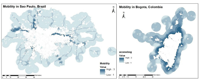
Figure 4. Mobility in Bogota and Sao Paulo.
Koch (2013) indicated that people in the suburban favelas in Sao Paulo had to walk over 30 minutes (approximately 2000 m) to bus stops. This study therefore used 2000 m as the average pedestrian distance from home to any transportation system. The methodology applied Kernel density to measure mobility to a scale of 1-3, in which 1 represented the least mobile areas and 3 represent the most mobile areas
3. Results
The result focuses on three aspects. First, the study estimated where informal residents are displaced by comparing formal and informal urban settlements over the years. Second, the study evaluated the average environmental risk to identify which population settle in areas with higher environmental risk. Third the research identified where the urban growth (formal and informal) was closer to areas with better mobility.
3.1 Formal and informal Urban Development
The results showed that Bogota had a fragmented urban growth from 2002 to 2018 (Figure 5).
Similar to what Inestroza et al. (2010) and Lopez -Morales et al. (2016) found out, informal development was more fragmented than formal development, which formed bigger clusters due to the suburbanization of the periphery with big housing projects. In addition, informal settlements were located mainly in the south of the metropolitan area, not forming large clusters closer to the main roads. Meanwhile, formal settlements exhibited a dispersed distribution in the expansion area.
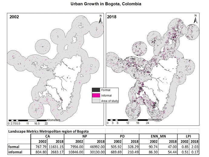
Figure 5. Formal and informal settlements in Bogota, 2002 and 2018.
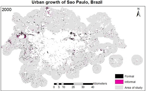
Figure 6a. Formal and informal settlements in Sao Paulo, 2000.
Figure 6b. Formal and informal settlements in Sao Paulo, 2017.
In Sao Paulo, the urbanized area increased 2.5 times between 2000 and 2017. the expansion was higher towards the south due to the mountainous topography and forest preserves located in the north (Figure 6). Formal development was higher than informal development. Sao Paulo's urban growth is more continuous than Bogota growing. Formal clusters were located close to commercial and industrial conglomerations on the city's east side. In the same way, Informal developments in Sao Paulo formed more continuous structures than Bogota’s unformal settlements; but they were located close to main roads and the city limit.
3.2 Environmental risk segregation
The results showed in Sao Paulo more formal urban expansion in higher Environmental risk areas. Meanwhile, in Bogota, informal expansion was in areas with lower environmental risk (Table 3).
Table 3. Statistics of environmental risk in Bogota and Sao Paulo for formal and informal settlements
Bogota's Environmental Risk on a scale from 1 to 3 |
||||
|
Mean |
Standard Deviation (STD) |
||
|
2002 |
2018 |
2002 |
2018 |
Formal |
1.65 |
1.648 |
0.23 |
0.27 |
Informal |
1.75 |
1.649 |
0.24 |
0.27 |
Sao Paulo Environmental Risk on a scale from 1 to 3 |
||||
|
Mean |
Standard Deviation (STD) |
||
|
2000 |
2017 |
2000 |
2017 |
Formal |
1.68 |
1.79 |
0.36 |
0.39 |
Informal |
1.73 |
1.75 |
0.35 |
0.37 |
In Bogota, the average environmental risk decreased over the years, which means that recently, more informal settlements built their houses in areas with a lower risk than before (Figure 7). In Sao Paulo, sites exclusively for informal developments in 2000 mixed with predominant formal regions in 2017 (Figure 8a and Figure 8b).
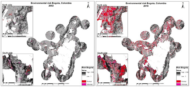
Figure 7. Environmental risk for formal and informal developments in Bogota, 2002 and 2018.
In both cities, formal development did not have a preference in location. Formal developments located on the north and east sides of Sao Paulo and the northeast side of Bogota were mainly recreational houses residential buildings with a suburban structure (reticular structure-more vegetation between constructions.) Therefore, other conditions such as the quality of the construction creates extra disadvantages for a high environmental risk that will be included in future research. The spatial analysis of the environmental risk of settlements in Bogota and Sao Paulo indicated that formal settlements did not push informal settlements to riskier areas based on the criteria considered in this study. In the case of Sao Paulo, the statistic showed an opposite pattern those formal areas settled to locations with higher environmental risk.
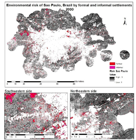
Figure 8a. Environmental risk for formal and informal developments in Sao Paulo, 2000.
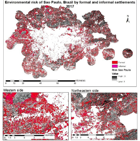
Figure 8b. Environmental risk for formal and informal developments in Sao Paulo, 2017.
3.3 Mobility segregation
Mobility of informal settlements improved over time in both urban areas. In general, people settled in areas with better mobility.
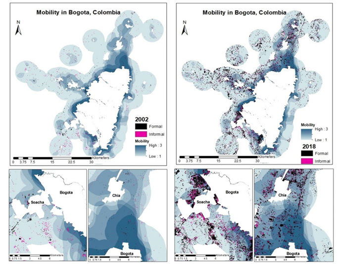
Figure 9. Mobility for formal and informal developments in Bogota, 2002 and 2018.
In Bogota, formal and informal developments have access to STP bus stops, routes, and highways connecting satellite cities in Bogota's metropolitan area (Figure 9). People in the metropolitan area settle more in areas with higher connection and transportation networks in the north. the mobility in the south is lower than the north. For that reason, urban growth in the south was not as prevalent to areas with high mobility than the north of the city. Still, the south sector had a sprawled formal development, not particularly close to any of the mobility elements analyzed in this study, creating a fragmented structure in the periphery.
The mobility in Sao Paulo shows a radial pattern, connecting satellite towns to the city center (Figure 10). The study showed that development in the periphery is not particularly associated with the BRT or main roads between towns. During the study period, the industrial activity of satellite towns accelerated formal urban development close to informal settlements in specific locations such as Barueri, Jandira, and Itapevi cities in the eastern side of the metropolitan area.
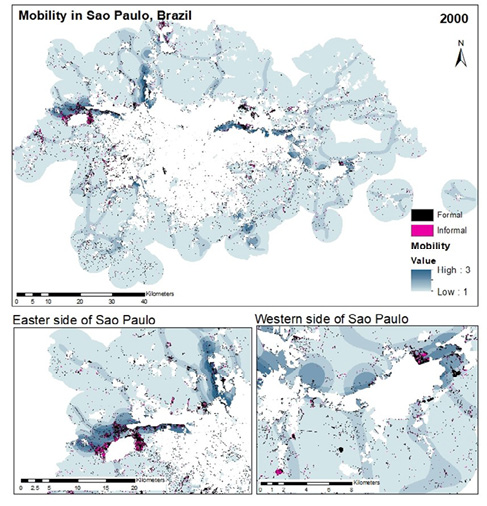
Figure 10a. Mobility for formal and informal developments in Sao Paulo, 2000.
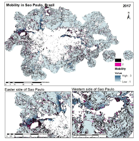
Figure 10b. Mobility for formal and informal developments in Sao Paulo, 2017.
Table 4. Statistics of mobility in Bogota and Sao Paulo for formal and informal settlements
Mobility of formal and informal locations in Bogota on a scale from 1 to 3 |
||||
|
Mean |
Standard Deviation (STD) |
||
|
2002 |
2018 |
2002 |
2018 |
Formal |
1.66 |
1.555 |
0.237 |
0.5272 |
Informal |
1.454 |
1.653 |
0.245 |
0.5499 |
Mobility of formal and informal locations in Sao Paulo on a scale from 1 to 3 |
||||
|
Mean |
Standard Deviation (STD) |
||
|
2000 |
2017 |
2000 |
2017 |
Formal |
1.69 |
1.47 |
0.64 |
0.56 |
Informal |
1.64 |
1.56 |
0.62 |
0.59 |
The Table 4 shows that mobility of poor residents has improved over the time. However, specific locations showed outlier patterns. For example, the industrial area at the west of Sao Paulo was populated principally by informal settlements in 2000, while formal developments had the most mobile locations in 2017. In Addition, in the south of Bogota, formal developments in 2018 occupied areas with the best mobility, and informal settlements are located in areas with low mobility. Nevertheless, those specific cases are beyond the scope of this research and a further study might be performed to prove a specific segregation pattern.
4. Discussion
The results showed exponential growth of formal development in the periphery of Latin American cities, promoted by market-oriented policies that attracted middle and high-class populations to the fringe of cities. However, the pattern analysis showed that formal development was not located exclusively in areas with lower environmental risk or high mobility. Even more, the statistics revealed that on average, informal settlements were found in areas with better mobility over the years in Bogota. This study shows that segregation was not a generalized in the urban growth in the periphery of Bogota and Sao Paulo between 2000 and 2018
In general, the pattern of informal settlements was similar in Bogota and Sao Paulo. Poor residents built their houses in the periphery but close to the urban fringe and main highways connected to jobs, education, and health care. Meanwhile, formal development exhibited several spatial characteristics, including industries and commercial activities close to cities and highways, suburban recreational condominiums far from the city, suburban houses attracted by the view located in steep slopes, and middle-class in gated communities close to highways for a short commute to downtowns by car. Unlike informal settlements, formal development was situated on the periphery by preferences.
At the scale of the study, there is no generalized form of segregation in all expansion areas. However, it pinpoints locations that privilege formal developments over informal settlements. The systematic segregation of informal settlements might not be generalized in all periphery, but it impacted more poor residents than other population. As Allen et al. (2017) suggested, the environmental risk is intensified by the construction conditions of informal housing.
Specific cases found in this study as outliers proved that segregation in the periphery of Latin American cities has had a similar pattern to the gentrification of city centers. First, the undeveloped land in the expansion of cities had an economic interest for investors, as Borsdorf and Hidalgo (2008) suggested. Second, the government opened regulations such as the Urban Strategic Plans and Zonal Plans, allowing enough freedom for private companies to develop in the expansion of cities. Third, the interest of private developers was to get a higher profit without considering the social difficulties of informal settlements caused by the new developments. Fourth, locations in the periphery were targeted as the most profitable, such as the north side of Bogota, and the such as Barueri, Jandira, and Itapevi sectors in Sao paulo. Fifth, the renewal of target areas responded to the trend that commodifies land according to the preference of high-income people. Finally, public services rates such as sewage and electricity are calculated by socio-economic strata of new developments, making it impossible for low-income residents to afford. The social inequalities mentioned by Jenks and Burgess (2003) and Klaufus (2013) were seen in this study as triggers of systematic spatial segregation in which profitable areas were targeted as commodities increasing the price lasnd and making imposible to poor population living in those areas.
In a city scale, the methodology used in this study was practical to locate target areas to have a more detail analysis. Landsat images proved to be functional in long-term observation of the city’s urban growth. Enhanced images through pan-sharpening improved spatial resolution that made more accurate the study. This Geospatial analysis mythology can be replicated in other cities adding more different elements to evaluate. The mapping of informal settlements in specific areas may be improved with images of higher resolution in a smaller scale.
The research workflow showed how urban development affects or segregates particular population locations at a metropolitan scale. Further, it indicated that the causes of segregation are complex, with a variety of physical, political, economic, and social factors. The study focused on environmental risk and mobility of informal settlements. However, the same method could be applied to incorporate other factors, such as access to schools, hospitals, and source of jobs, to fully understand how segregation works. The variables also might be adjusted to use high-resolution images and integrate quality of constructions to identify susceptibility of informal settlements in steep slopes.
In Latin America, each country created specific market-oriented policies that reinforced capitalist urban development, such as partial plans in Colombia and Mexico. However, since the study only focused on two Latin American megacities, future studies may establish a stronger relationship between urban policies and segregating urban patterns in Latin America.
5. Conclusion
This study aimed to understand the patterns of development in the periphery of Latin American cities and whether informal settlements were forced to migrate to isolated areas or areas exposed to environmental hazards.
The study showed that segregation not was generalized pattern in the periphery of the Latin American cities. The displacement by social classes in in Bogota and Sao Paulo is complex, and systematic. At the study scale, informal settlements migrated to locations with better environmental conditions, and mobility.
The research was able to identify locations where poor residents were displaced. The methodology proved to be effective to locate sectors where segregation can be identified. Those areas will be study in the future in a focused manner on a smaller scale and with higher resolution images.
References
Amparo-Alves, J. (2013). From Necropolis to Blackpolis: Necropolitical governance and black spatial praxis in São Paulo, Brazil. Antipode, 46(2), 323–339. DOI: http://dx.doi.org/10.1111/anti.12055
Angotti, T. (2013). Urban Latin America. Latin American Perspectives, 40(2), 5-20. http://dx.doi.org/10.1177/0094582x12466832
Aguilar, A. G., Ward, P. M., & Sr, C. S. (2003). Globalization, regional development, and megacity expansion in Latin America: Analyzing Mexico City's peri-urban hinterland. Cities, 20(1), 3–21. http://dx.doi.org/10.1016/s0264-2751(02)00092-6
Allen, A., Belkow, T., Escalante Estrada, C., de los Ríos, S., Kamiya, M., Miranda, L., Wesely, J. & Zilbert Soto, L. (2017). De la mitigación de desastres a la interrupción de trampas de riesgo: La experiencia de aprendizaje-acción de clima sin riesgo. REDER, 1(1), pp.6-28. Comisión Económica para América Latina y el Caribe, CEPAL (2018). La pobreza aumentó en 2016 en América Latina y alcanzó al 30,7% de su población, porcentaje que se mantendría estable en 2017. https://www.cepal.org/es/comunicados/la-pobreza-aumento-2016-america-latina-alcanzo-al-307-su-poblacion-porcentaje-que-se.
Bassett, T. E., & Marpillero-Colomina, A. (2013). Sustaining mobility: Bus rapid transit and the role of local politics in Bogotá. Latin American Perspectives, 40(2), 135–145. http://dx.doi.org/10.1177/0094582X12468867
Borsdorf, A., & Hidalgo, R. (2008). New dimensions of social exclusion in Latin America: From gated communities to gated cities, the case of Santiago de Chile. Land Use Policy, 25(2), 153–160. http://dx.doi.org/10.1016/j.landusepol.2007.04.001
Budds, J., & Teixeira, P. (2005). Ensuring the right to the city: Pro-poor housing, urban development and tenure legalization in São Paulo, Brazil. Environment and Urbanization, 17(1), 89–114. http://dx.doi.org/10.1177/095624780501700105
Castro-Correa, C., Ibarra, I., Lukas, M., Ortiz, J., & Sarmiento, J. P. (2015). Disaster risk construction in the progressive consolidation of informal settlements: Iquique and Puerto Montt (Chile) case studies. International Journal of Disaster Risk Reduction, 13(1), 109–127. http://dx.doi.org/10.1016/j.ijdrr.2015.05.001
Codina, P. R. (2005). Formalizing the informal city: designing for development in a Peruvian shantytown (thesis). University of Maryland. https://drum.lib.umd.edu/handle/1903/2702
Gilbert, A. (1998). The Latin American city. Monthly Review Press. United Kingdom.
Guzman, L. A., Oviedo, D., & Rivera, C. (2017). Assessing equity in transport accessibility to work and study: The Bogotá region. Journal of Transport Geography, 58, 236-246. http://dx.doi.org/10.1016/j.jtrangeo.2016.12.016
Hardoy, J., & Pandiella, G. (2009). Urban poverty and vulnerability to climate change in Latin America. Environment and Urbanization, 21(1), 203–224. http://dx.doi.org/10.1177/0956247809103019
Hyman, J. (2018). Cartographies of power: Unequal urban development and the racialization of space in São Paulo (thesis). University of San Francisco.
Inostroza, L., Baur, R., & Csaplovics, E. (2010). Urban sprawl and fragmentation in Latin America: A comparison with European cities. The myth of the diffuse Latin American city. Journal of environmental management, 115, 87–97. http://dx.doi.org/10.1016/j.jenvman.2012.11.007
Inostroza, L. (2016). Measuring urban informality in Latin America. GIS spatial assessment of informal urban development in Santiago De Chile. Procedia Engineering, 161(1), 1631–1638. http://dx.doi.org/10.1016/j.proeng.2016.08.638
Inostroza, L., & Tábbita, J. H. (2016). Informal urban development in the Greater Buenos Aires Area: A quantitative-spatial assessment based on households' physical features using GIS and principal component analysis. Procedia Engineering, 161, 2138–2146. http://dx.doi.org/10.1016/j.proeng.2016.08.806
Jaitman, L. (2015). Urban infrastructure in Latin America and the Caribbean: Public policy priorities. Latin American Economic Review, 24(1), 13. http://dx.doi.org/10.1007/s40503-015-0027-5
Jenks, M., & Burgess, R. (2003). Compact cities: Sustainable urban forms for developing countries. Spon Press. New York, NY. http://search.ebscohost.com/login.aspx?Direct=true&scope=site&db=nlebk&db=nlabk&AN=77274
Klaufus, C. (2013). The Right to a city: Changing peri-urban landscapes in Latin America. In book: Rethinking urban inclusion: Spaces, mobilizations, interventions. CES Centre for Social Studies, University of Coimbra. 487-503. http://dx.doi.org/10.13140/RG.2.1.1789.3847
Kohli, D., Sliuzas, R., Kerle, N., & Stein, A. (2012). An ontology of slums for image-based classification. Computers, Environment and Urban Systems, 36(2), 154–163. http://dx.doi.org/10.1016/j.compenvurbsys.2011.11.001
Koch, J. (2013). Transportation in the favelas of Rio de Janeiro. Lincoln Institute of Land Policy. Cambridge, MA. https://www.lincolninst.edu/sites/default/files/pubfiles/koch_wp13jk1.pdf
Lopez-Morales, E., Shin, H. B., & Lees, L. (2016). Latin American gentrifications. Urban Geography, 37(8), 1091–1108. http://dx.doi.org/10.1080/02723638.2016.1200335
Maceratini, E. (2011, July). Informal city: The cases of Bogotà and Rio de Janeiro. The International RC21 conference. Amsterdam Institute for Social Science Research – Urban Studies, University of Amsterdam – The Netherlands. http://www.rc21.org/conferences/amsterdam2011/edocs/Session%2029/RT29-1-Maceratini.pdf
Mahabir, R., Croitoru, A., Crooks, A. T., Agouris, P., & Stefanidis, A. (2018). A Critical review of high and very high-resolution remote sensing approaches for detecting and mapping slums: Trends, challenges and emerging opportunities. Urban Science, 2(1), 8. http://dx.doi.org/10.3390/urbansci2010008
Montaña, M. C., & Borrero, O. A. (2015). Los planes parciales en Colombia: Evaluación de la aplicación de planes parciales y reajuste del suelo en siete cuidades Colombianas, 2006-2013. Instituto de Estudios del Ministerio Público. Cámara de Comercio de Bogotá. Bogotá. https://bibliotecadigital.ccb.org.co/handle/11520/13166
Moreno, C., & Miralles-Guasch, C. (2017). The bicycle as a real feeder to the transmilenio system in Bogota and Soacha. International Journal of Transport Development and Integration, 1(1), 92-102. http://dx.doi.org/10.2495/TDI-V1-N1-92-102
Rojas, C., Muñiz, I., & Pino, J. (2013). Understanding the urban sprawl in the mid-size Latin American Cities through the urban form: Analysis of the Concepcion Metropolitan Area (Chile). Journal of Geographic Information System, 5(3), 222–234. http://dx.doi.org/10.4236/jgis.2013.53021
Silva, H. M. B., & Ceneviva, L. V. 1996. Favelas y fraccionamientos irregulares en São Paulo. In El acceso de los pobres al suelo urbano. Centro de estudios mexicanos y centroamericanos, 169-218. http://dx.doi.org/10.4000/books.cemca.929
Tomasiello, D. B., Giannotti, M., Arbex, R., & Davis, C. (2019). Multi-temporal transport network models for accessibility studies. Transactions in GIS, 23(2), 203–223. http://dx.doi.org/10.1111/tgis.12513
Wenzel, F., Bendimerad, F., & Sinha, R. (2007). Megacities–megarisks. Natural Hazards, 42(3), 481–491. http://dx.doi.org/10.1007/s11069-006-9073-2
Yañez-Pagans, P., Martinez, D., Mitnik, O. A., Scholl, L., & Vazquez, A. (2019). Urban transport systems in Latin America and the Caribbean: Lessons and challenges. Latin American Economic Review, 28(1), 15. http://dx.doi.org/10.1186/s40503-019-0079-z
1 Department of Geography & Environmental Studies at Northeastern Illinois, University in Chicago, Illinois, USA, e-mail: smmoralesd@gmail.com. ORCID: https://orcid.org/0000-0003-1215-4018.
77-97