Revista Cartográfica 106 | enero-junio 2023 | Artículos
ISSN (impresa) 0080-2085 | ISSN (en línea) 2663-3981
DOI: https://doi.org/10.35424/rcarto.i106.2120
Este es un artículo de acceso abierto bajo la licencia CC BY-NC-SA 4.0
Dendrogeomorphology as a tool to depict hydrogeomorphic processes in the tropics
La dendrogeomorfología como una herramienta para representar procesos hidrogeomorfológicos en los trópicos
Adolfo Quesada-Roman1
Recibido 8 de agosto de 2022; aceptado 24 de septiembre de 2022
Abstract
Climatic and anthropogenic changes cause the deprivation of distinct ecosystems in Costa Rica, transforming climatic, ecological, and geomorphic conditions. The high tropical biodiversity of Costa Rica and the tropics is suitable to improve the understanding of hydrogeomorphic process dynamics and to produce baseline data on past disasters in scarce-data regions. The principal motivation to connect natural hazards and dendrochronology on tropics is the desire to create methods that can reduce its exposure and vulnerability. The principal research aim of this study is to give reference data that can improve the understanding of hydrogeomorphic processes and to explore the potential of tropical trees in dendrochronological applications. This paper combines remote sensing, meteorological assessments, and dendrochronology analyses, hydraulic modelling, and risk assessments. This innovative research describes the reduced understanding in treering analysis in Costa Rica related with past disasters and their linkage to climate. This study will likely contribute to the implementation of new methodologies in disaster risk research, and it will promote future adaptation strategies in the most biodiverse region of the world.
Key words: dendrochronology, natural hazards, disaster risk reduction, tropics, developing countries.
Resumen
Los cambios climáticos y antropogénicos están contribuyendo a la degradación de diferentes ecosistemas en Costa Rica, alterando así las condiciones climáticas, ecológicas y geomórficas. La hipótesis de este trabajo es que la alta biodiversidad tropical de Costa Rica y los trópicos es adecuada para mejorar la comprensión de la dinámica de los procesos hidrogeomórficos y generar datos de referencia sobre desastres pasados en una región con datos limitados. La principal motivación para vincular las amenazas naturales y la dendrocronología en esta región de baja latitud es la persistente escasez de datos sobre procesos hidrogeomórficos pasados y el deseo de definir métodos que puedan reducir su exposición y vulnerabilidad. Por lo tanto, el principal objetivo de investigación de este estudio fue proporcionar datos de referencia que puedan mejorar la comprensión de los procesos hidrogeomórficos, así como explorar el potencial de las especies de árboles tropicales en aplicaciones dendrocronológicas. Por lo tanto, este estudio combina sensores remotos, evaluaciones meteorológicas y técnicas de anillos de árboles con análisis estadísticos, modelos hidráulicos y evaluaciones de riesgos. La naturaleza innovadora de esta investigación describió la muy limitada experiencia disponible en términos de análisis de anillos de árboles en Costa Rica y la clara falta de comprensión sobre desastres pasados y su vínculo con el clima. Es probable que este estudio contribuya a la implementación de nuevas metodologías en la investigación del riesgo de desastres y, con suerte, contribuirá a futuras estrategias de adaptación en los trópicos, la región con mayor biodiversidad del mundo.
Palabras clave: dendrocronología, amenazas naturales, reducción del riesgo de desastres, trópicos, países en desarrollo.
1. Introduction
Weather-related disasters tend to sum most casualties and economic losses every year at a worldwide level. Forecasting hydrometeorological hazards remains challenging despite improved knowledge of potential triggers and sophisticated climato-logical models. Furthermore, climate change will affect the occurrence and the nature of processes, rendering accurate predictions even more challenging in data-scarce regions. Global warming is expected to lead to an increase in flooding over the decades to come, with delicate consequences on livelihoods (UNDRR, 2019; Pinos & Quesada-Román, 2022). Therefore, more research is therefore critically needed to reduce uncertainties of climate change scenarios related to climate and hydrological models (Kundzewicz et al., 2018).
The tropics count for approximately 20% of the world land surface (Peel et al., 2007), but they accommodate the 50% of the global population (Tatem, 2017), and are affected by substantial land-use changes (Hettig et al., 2016). Moreover, developing countries have fast urbanization and increasing population density processes resulting in greater exposure and vulnerability (Mitchell et al., 2015). Consistently, low-latitude regions usually present high values for expected socio-economic losses due to earthquakes, volcanic risks, landslides, floods, storm surges, and tropical cyclones (Figure 3). Developing countries in the low latitudes are largely more affected by disasters worldwide (Noy, 2009).
Most common hydrometeorological hazards on tropics are landslides, floods, tropical storms, and droughts (UNISDR, 2009). On one hand, tropical regions are hotspots for landslides (Lin et al., 2017). Landslides are linked to rainfall intensity and duration (Segoni et al., 2018; Carrión et al., 2021). The past and projected global mortality risk of landslide around the world shows a close link with tropical mountain regions (Kirschbaum et al., 2015; Shi & Karsperson, 2015). On the other hand, tropical floods are controlled by land-use changes, floodplain occupation, intense yearly or extraordinary rainfall processes (Syvitski et al., 2014). Different climatic modes (e.g., AMO and ENSO) control the occurrence of extraordinary rainfall events in low latitudes such as tropical cyclones (Goldenberg et al., 2001; Sun et al., 2017; NOAA, 2022). Thus, bigger inlets and faster change rates have recently caused more extreme tropical floods (Wohl, 2006).
Hydrogeomorphology is an interdisciplinary discipline focusing on interactions of hydrologic with geomorphic processes in their temporal and spatial dimensions (Sidle & Onda, 2004). Depending on the scale, climate, topography, soils, vegetation, and land use affect differentially hydrogeomorphic processes. Most catchment studies still lack the information to measure runoff, erosion processes, and sediment transport processes. There is a necessity to perform these studies at different scales, combined with long-term catchment monitoring to generate field data to parameterize, test, and accurately calibrate numerical models (Sidle et al., 2017). Nonetheless, such information normally lacks in low latitudes (Wohl et al., 2012).
Dendrogeomorphic applications provide results that can reduce the information gaps of regions with data scarcity. Botanical evidence is a critical proxy to determine the magnitude and frequency of hydrogeomorphic processes, e.g., floods, landslides, and debris flows (Stoffel & Bollschweiler, 2008; Stoffel et al., 2013; Stoffel & Corona, 2014). A key implication of the vegetation-hydrogeomorphology linkage is that woody plants can allow reconstruction of ecological and hydrogeomorphic processes over several decades to centuries (Stoffel & Wilford, 2012). The hydrogeomorphic process information gathered by means of dendrogeomorphic techniques can certainly improve model uncertainties, event reconstruction and hazard zonation (Allen et al, 2018).
Since data on past events is critically lacking in tropical regions, this research aims to investigates the potential of tropical dendrochronology to assess hydrogeomorphic processes and to reduce uncertainties for risk assessments. Tropical mountains are dynamic regions with energetic torrents that commonly comprise dense vegetation, making possible the dendrogeomorphology implementation as a reliable method to assess hydrogeomorphic processes. Therefore, this research will present geomorphic, hydrological, dendrochronological, and risk assessment applications made in Costa Rica as a tropical/development study example for limited data regions/countries.
2. Materials and methods
2.1. Costa Rica: an Earth sciences’ small lab
Tectonic activity of Costa Rica is composed by the interaction subduction margin of the Cocos and Caribbean plates, the microplate of Panama, and the subduction of the Cocos volcanic ridge (Alvarado et al., 2017). The country is divided in three morphotectonic units: a forearc, a volcanic front, and a backarc that comprise the country’s lithology (Marshall, 2007). The forearc widens along the Pacific seaside with intricate morphologies since Cretaceous age (Denyer & Alvarado, 2007). The volcanic front comprises the main cordilleras made mostly of volcanic and sedimentary rocks since Paleogene age (Alvarado, 2021). The backarc spreads since the Caribbean plains of Tortuguero’s flatlands to the hilly relief of the south Caribbean (Quesada-Román & Pérez-Briceño, 2019). The principal geomorphic dynamics in the country are fluvial, volcanic, and coastal, but some karstic and glacial areas also pop up (Quesada-Román & Pérez-Umaña, 2020).
The continuous sequence of cordilleras that cross over Costa Rica with an NW-SE alignment characterizes the Pacific and Caribbean basins. This topographic barrier also controls the amount of rainfall in each basin: Pacific and Caribbean (Amador et al., 2010; Quesada-Román et al., 2020b). The Pacific climate shows a bimodal precipitation regime, but it is hard to identify a dry period in the Caribbean climate (Castillo & Amador, 2020). The Caribbean side’s annual rainfall totals are up to 3000 mm; they are generally below 3 m in the Pacific. These climatological characteristics justify than over a ninety percent of disasters in the country are hydrometeorological. Moreover, sixty percent are floods and thirty percent are mass movements (Campos-Durán & Quesada-Román, 2017; LA RED, 2022).
The country’s population reached 5 million people in 2018, and, over the last decades, its dynamics changed from a significant rurality to a strong urban trend achieving three quarts of the inhabitants in 2011. Mass movement and flooding research have been vast in different regions of the country but mostly in Spanish (Quesada-Román, 2021; 2022). Nevertheless, the production of detailed-scale hazard maps and its combination with vulnerability and risk calculation is scarce (Quesada-Román et al., 2021c).
2.2. Fieldwork
Fieldwork for this study summed the experience working in this territory since 2010, but specifically for this research between 2016 and 2019. This study analyzed the hillslopes of the Miravalles volcano, low and flatlands of Upala at northern Costa Rica, and Térraba catchment at southern Costa Rica. Geomorphological mapping fieldwork procedures were made characterizing gravitational and fluvial landforms and checking the pre-mapping subproducts in all the sites. During the field surveys dendrogeomorphic techniques were used taking samples from impacted trees to reconstruct the water heights using their scars in Térraba catchment. These heights were after used to model hydraulic models and calculate peak flows. During field-works drone flights were made to survey river reaches that eventually were used in hydraulic models.
2.3. Statistical analysis
This study applied Pearson correlation equations and performed generalized linear models (GLM) to describe statistically significant linkages between obtained variables with other environmental parameters. Based on the Akaike Information Criterion (AIC), we used a backward selection to contrast the full models against the alternative models. Using z-score co-variables were standardized (regression coefficient divided by standard error). Model variables were used to evaluate the weight of each interaction explaining the studied parameters. Examples of these applications were: a) variables controlling landslides occurrence after an earthquake and hurricane in 2016 at northern Costa Rica (Quesada-Román et al., 2019), and b) geomorphic and hydrological parameters influencing peak discharges at local and regional scale at southern Costa Rica (Quesada-Román et al., 2020a, 2022).
Two-dimensional (2D) hydrodynamic models using IBER were used to model water depth of flood event related to Tropical Storm Nate in 2017 in seven stream reaches (Quesada-Román et al., 2020a). Bed friction was estimated in the reaches with Manning's n roughness coefficient as homogenous roughness units. The following Manning values were used: n= 0.075 (main channel), 0.16 (forest), and 0.08 (sparse vegetation). Modeled successive inlet discharges based on historical extremes were computed. Available data from hydrological data of yearly maximum flows from eight stations from 1962-2019 was employed to apply a regional flood-frequency method employing the Bayesian MCMC (Markov Monte Carlo Chain) algorithm (Quesada-Román et al., 2022).
2.4. Risk mapping
First, several morphometric and morphogenetic maps were made in the different stages and places of this work (Quesada-Román & Villalobos-Chacón, 2020). The study follows a threefold stepwise geomorphological mapping which is inte-grated by a pre-mapping, fieldwork, and post-mapping phase. Those maps are the baseline for other flood and landslides maps. A flood risk assessment merged the regional flood-frequency study coupled with dendrochronology (hazard), a detailed cartography of population/infrastructure density (exposure), and a social development index (vulnerability) in one of the study applications in Térraba catchment (Quesada-Román et al., 2022).
3. Results
3.2. Can earthquakes, hurricanes, and landslides interact?
The Miravalles volcano, in northern Costa Rica, was impacted by an earthquake of 5.4 Mw (July, 2016) and followed by extraordinary precipitations associated to the Hurricane Otto (category 3) just a few weeks after (November, 2016). Hurricane Otto passing left roughly 300 mm of rain over the volcano. Using a general linear regression model (GLM), it was possible to characterize the interactions among the parameters influencing landslides (epicenter distance, precipitation, altimetry, and slope).
The cascading 2016 disaster caused 942 mass movements (Figure 1). 62% of them occurred between 3 to 6 km from the prior epicenter and in the E, SE, and S slopes of Miravalles volcano where local faults density concentrate, and precipitation summed maximum values throughout the cyclone. The GLM validates a combined earthquake-hurricane coupling with greater massmovements densities near the epicenter, at zones with greater rainfall totals, steep and higher regions.
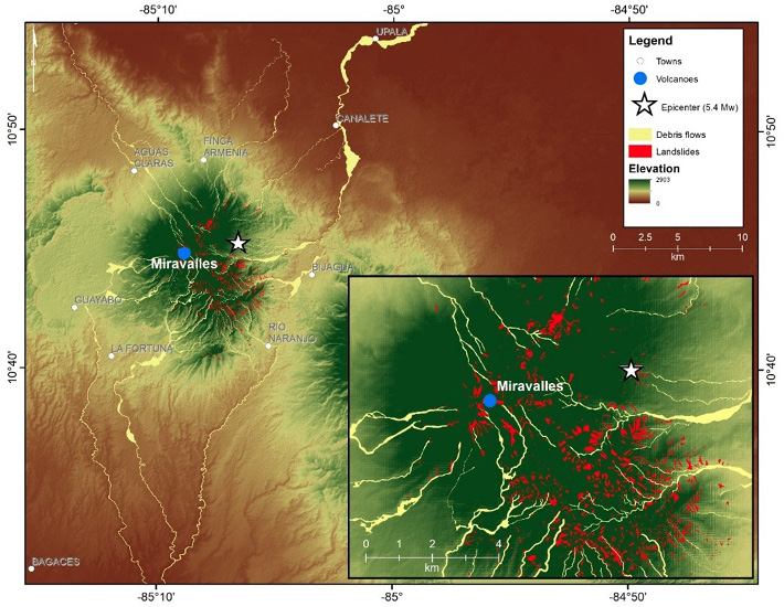
Figure 1. Debris flows and landslides generated by Hurricane Otto over Miravalles volcano.
The application of Sentinel-1 synthetic aperture radar and WorldView-3 and -4 images helped to map the flooded areas derived by Hurricane Otto in Upala municipality (Figure 3). Debris flows impacted roughly 27 km2 (Figure 2) and moved down the slopes as flash floods in approximately 74 km2 (Figure 4), with eight casualties in the vicinity of the Miravalles volcano and roughly 10 million US$ of economic impacts in Bagaces and Upala municipalities.
3.3. Botanical evidence, hydrological, and disaster risk assessments
The Térraba catchment in central-south has the bigger area and peak discharge records in Costa Rica with 4765 km2. Seven random sample places along the catchment were used to reconstruct the peak discharge of a recent tropical cyclone (Tropical Storm Nate, 2017) employing botanical evidence, especially scars on the trees (Figure 5). Interestingly, trees on cut banks or terraces have minimal uncertainties among observed and modeled heights of flows, not in straight channel reaches (Figure 6).
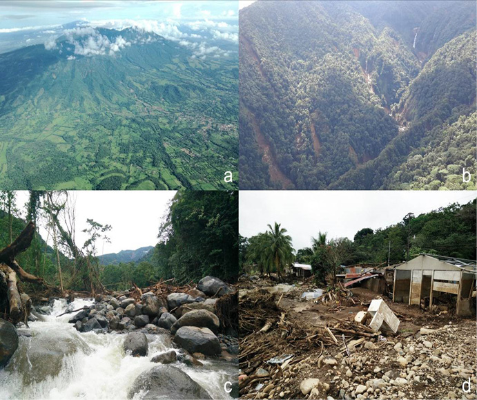
Figure 2. a) Flights over Miravalles volcano following the cyclone. b) Mass move-ments on Miravalles volcano NE slope. c) Large blocks and wood moved along the NE volcano slope. d) The debris flows produced four casualties and immense eco-nomic losses.
In the second phase, the regional flood-frequency analyses were performed. The study combined a dendrochronology assessment and peak discharge calculation to obtain flood return periods. These return periods were merged with the Topographic Wetness Index (TWI) to ascertain regional flood hazards throughout riverbeds and surrounding areas. Flood exposure was determine using the population and infrastructure density. Flood vulnerability was based on the social development index (IDS, 2017) which merges fourteen socioeconomic parameters nationally (MIDE-PLAN, 2017).
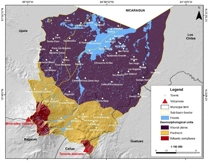
Figure 3. Geomorphological units and Hurricane Otto flash floods in Upala municipality.
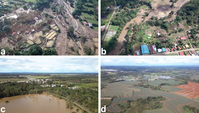
Figure 4. Flights over Upala after the passing Hurricane Otto. Debris flows and flash floods carried large wood (a). Downstream the floodplains spread out (b). Rice and pineapple croplands, and forest/wetlands fragmented areas were the most flooded areas (c, d).
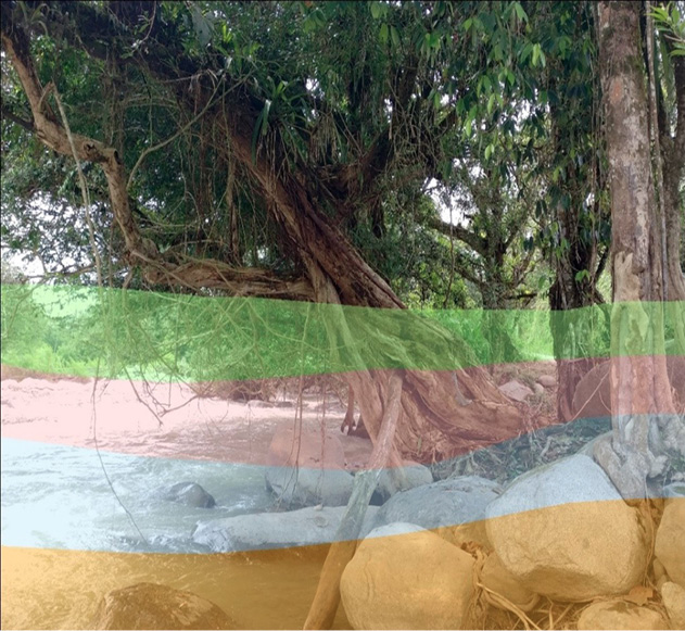
Figure 5. Successive inlet modeled discharges using historical extremes, dendrogeomorphology, and a two-dimensional hydrodynamic model to calculate peak discharges.
The highest risk values are distributed throughout the catchment in confined sites but mainly located in General, Unión, Pejibaye, Ceibo, and Limón catchments, which are very populated, less favored, or indigenous regions. Medium and low risk results responded to less populated catchments, mainly agricultural areas such as Pacuar, some parts of Volcán, General, and Coto Brus. The transdisciplinary approaches combination proved useful in the scarce-information Térraba catchment and about 6000 people live in looding risky areas (Figure 7).
4. Discussion
4.1. Monitoring earthquake-cyclones interaction regions
The consequent occurrence of earthquakes and extraprdinary hydrometeorological events trigger compound and amplified disasters (Wallemacq & House, 2018). Central American tectonic dynamics make this region remarkably vulnerable to mass movements (Alvarado et al., 2017). Moreover, high weathering and wet soils conditions are ideal for earthquake-induced landslides (Bommer & Rodríguez, 2002). In addition, high precipitation in Central America triggers several landslides every year. Consequently, the isthmus has a very high link among mean daily rainfall totals and mean daily landslides worldwide (Froude & Petley, 2018). Therefore, a good recommendation is to monitor earthquake previously affected regions during subsequent extraordinary rainfall events (Piciullo et al., 2018).
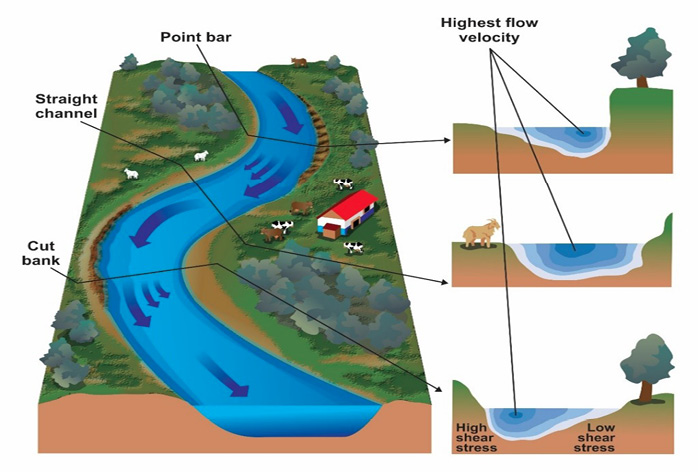
Figure 6. Tree’s geomorphic location controls the uncertainties among observed (scars) and calculated peak discharge. Uncertainties are lower on stable fluvial landforms such as point bars, terraces, and cut banks.
Large wood on debris-flows generated critical impacts on infrastructure during the Hurricane Otto. Tropical conditions promote great wood decay and therefore catchments can transport high capacity of trunks linked with large peak discharge (Cadol et al., 2009; Wohl et al., 2017). Hence, large wood is a risk enhancer of infrastructure damage, block river channels, and intensify floods (Ruiz-Villanueva et al., 2016). An extraordinary number of large wood pieces were withdrawn from the channel network around Miravalles volcano days after the event.
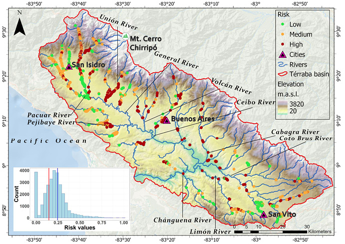
Figure 7. Flood risk determination for the Térraba catchment at central-south Costa Rica.
4.2. Tropical dendrogeomorphic peak discharge calculation reliability
The use of UAV photogrammetry can generate high-resolution orthoimages which can reduce topography uncertainties. This information is key to produce good digital surface models and precise hydraulic models. The study results are even similar or lower than temperate regions such as Poland (Ballesteros-Cánovas et al., 2016), United States (Yanosky & Jarrett, 2002), Canada (Gottesfeld, 1996), Spain (Ballesteros-Cánovas et al., 2011a, b; Victoriano et al., 2018), Canary Islands (Garrote et al., 2018), or Bhutan (Speer et al., 2019).
The trees located on point bars and straight channels are impacted by higher flow velocities and Froude numbers in the hydraulic model. For future assessments, to significantly reduce the time in dendrogeomorphic sampling and to enhance results is compulsory to use more stable landforms such as cut banks and alluvial terraces. These results were consistent with previous studies (Ballesteros-Cánovas, 2011a; Gottesfeld, 1996; Yanosky & Jarret, 2002; Victoriano et al., 2018).
4.3. Are disaster risk assessments possible in scarce-data countries?
Regional flood risk assessments in large scale geomorphic units are achievable using a group of general (systematic hydrological data, socioeconomic indexes) and high-resolution inputs (UAV images, hydraulic models, detailed population densitydata). Térraba catchment most inhabitants are considered to live in rural settings and associated with agriculture (INEC, 2020). Community capital and spatial variability define rural areas disaster resilience (Cutter et al., 2016). Communities closer to urban centers have an improved capacity dealing with flooding (Jamshed et al., 2020). Moreover, developing countries’ rural areas are extremely vulnerable to disasters. Furthermore, its vulnerability responds with high migration levels, dispersed benefit from social protection programs, and scarcer or no savings to soft the impacts (Deria et al., 2020). Additionally, Térraba catchment comprise numerous indigenous territories that should be evaluated by their knowledge and cultural characteristics (Kelman et al., 2012). Therefore, rural, and indigenous revenues rely on livelihood assets surrounded by vulnerable or protected ecosystems (UNDRR, 2019). Therefore, developing countries’ lower income households in rural are greatly affected by the impact of disasters (Jakobsen, 2012; Arouri et al., 2015). For instance, public policies such as poverty reduction, territorial planning, and environmental management should be primary instruments governing disaster risks (Lavell & Maskrey, 2014).
5. Conclusions
This research found a set of future research lines for natural hazards and dendrochronology in Costa Rica and the tropics. The study of hydrogeomorphic processes can be improved through the creation of higher-resolution baseline data, especially also in terms of better imagery (e.g., satellite, airborne, drones, LiDAR) and more intensive fieldwork to generate better geomorphic maps and statistical modelling to develop suitable natural hazard assessments and zonation. Previously affected mountain regions by earthquakes must be monitored in extraordinary precipitation events to anticipate further disasters. Areas where mass movements generated by earthquakes and subsequent strong rainfall events can be triggered are necessary to be studied to minimize casualties and losses in developing countries. Flood-frequency analyses with dendrogeomorphic estimations and hydrological measurements can be precisely used to calculate cyclone-induced peak discharges and floods. Coarse and detailed data can be useful implementing regional flood risk evaluations in large-scale catchments. A regional flood-frequency approach in parallel with dendrogeomorphology and risk assessment is a practical contribution for territorial planning strengthening the resilience of tropical catchments populations. This multidisciplinary procedure can be employed in countries where hydrlogical reference information is limited.
References
Allen, S. K., Ballesteros-Canovas, J., Randhawa, S. S., Singha, A. K., Huggel, C., & Stoffel, M. (2018). Translating the concept of climate risk into an assessment framework to inform adaptation planning: Insights from a pilot study of flood risk in Himachal Pradesh, Northern India. Environmental science & policy, 87, 1-10. https://doi.org/10.1016/j.envsci.2018.05.013
Alvarado, G. E., Benito, B., Staller, A., Climent, A., Camacho, E., Rojas, W., Marroquín, G., Molina, E., Talavera, J. E., Martínez-Cuevas, S., & Lindholm, C. (2017). The new Central American seismic hazard zonation: mutual consensus based on up to day seismotectonic framework. Tectonophysics, 721, 462-476. https://doi.org/10.1016/j.tecto.2017.10.013
Alvarado, G. E. (2021). Costa Rica y sus volcanes. San José, Costa Rica: EUCR, EUNA, ETCR.
Amador, J. A., Alfaro, E. J., Rivera, E. R., & Calderón, B. (2010). Climatic features and their relationship with tropical cyclones over the Intra-Americas seas. In Hurricanes and climate change, 149-173. Springer, Dordrecht. https://doi.org/10.1007/978-90-481-9510-7_9
Arouri, M., Nguyen, C., & Youssef, A. B. (2015). Natural disasters, household welfare, and resilience: evidence from rural Vietnam. World development, 70, 59-77. https://doi.org/10.1016/j.worlddev.2014.12.017
Ballesteros, J. A., Bodoque, J. M., Díez-Herrero, A., Sanchez-Silva, M., & Stoffel, M. (2011). Calibration of floodplain roughness and estimation of flood discharge based on tree-ring evidence and hydraulic modelling. Journal of Hydrology, 403(1-2), 103-115. https://doi.org/10.1016/j.jhydrol.2011.03.045
Ballesteros Canovas, J. A., Eguibar, M., Bodoque, J. M., Díez-Herrero, A., Stoffel, M., & Gutiérrez-Pérez, I. (2011). Estimating flash flood discharge in an ugauged mountain catchment with 2D hydraulic models and dendrogeomorphic palaeostage indicators. Hydrological Processes, 25(6), 970-979. https://doi.org/10.1002/hyp.7888
Ballesteros-Cánovas, J. A., Stoffel, M., Spyt, B., Janecka, K., Kaczka, R. J., & Lempa, M. (2016). Paleoflood discharge reconstruction in Tatra Mountain streams. Geomorphology, 272, 92-101. https://doi.org/10.1016/j.geomorph.2015.12.004
Bommer, J. J., & Rodrı́guez, C. E. (2002). Earthquake-induced landslides in Central America. Engineering Geology, 63(3-4), 189-220. https://doi.org/10.1016/S0013-7952(01)00081-3
Cadol, D., Wohl, E., Goode, J. R., & Jaeger, K. L. (2009). Wood distribution in neo-tropical forested headwater streams of La Selva, Costa Rica. Earth Surface Processes and Landforms, 34(9), 1198-1215. https://doi.org/10.1002/esp.1800
Campos-Durán, D. F., & Quesada-Román, A. (2017). Impacto de los eventos hi-drometeorológicos en Costa Rica, periodo 2000-2015. Geo Uerj, (30), 440-465. https://doi.org/10.12957/geouerj.2017.26116
Carrión-Mero, P., Montalván-Burbano, N., Morante-Carballo, F., Quesada-Román, A., & Apolo-Masache, B. (2021). Worldwide research trends in landslide science. International journal of environmental research and public health, 18(18), 9445. https://doi.org/10.3390/ijerph18189445
Castillo, R., & Amador, J. A. (2020). Precipitation and Temperature in Costa Rica at the End of the Century Based on NEX-GDDP Projected Scenarios. Atmosphere, 11(12), 1323. https://doi.org/10.3390/atmos11121323
Cutter, S. L., Ash, K. D., & Emrich, C. T. (2016). Urban–rural differences in disaster resilience. Annals of the American Association of Geographers, 106(6), 1236-1252. https://doi.org/10.1080/24694452.2016.1194740
Denyer, P., & Alvarado, G. E. (2007). Mapa geológico de Costa Rica. Escala 1:400 000. Librería Francesa. San José, Costa Rica.
Deria, A., Ghannad, P., & Lee, Y. C. (2020). Evaluating implications of flood vulnerability factors with respect to income levels for building long-term disaster resilience of low-income communities. International Journal of Disaster Risk Reduction, 48, 101608. https://doi.org/10.1016/j.ijdrr.2020.101608
Froude, M. J., & Petley, D. N. (2018). Global fatal landslide occurrence from 2004 to 2016. Natural Hazards and Earth System Sciences, 18(8), 2161-2181. https://doi.org/10.5194/nhess-18-2161-2018
Garrote, J., Díez-Herrero, A., Génova, M., Bodoque, J. M., Perucha, M. A., & May-er, P. L. (2018). Improving flood maps in ungauged fluvial basins with dendro-geomorphological data. An example from the Caldera de Taburiente National Park (Canary Islands, Spain). Geosciences, 8(8), 300. https://doi.org/10.3390/geosciences8080300
Goldenberg, S. B., Landsea, C. W., Mestas-Nuñez, A. M., & Gray, W. M. (2001). The recent increase in Atlantic hurricane activity: Causes and implications. Science, 293 (5529), 474-479. https://doi.org/10.1126/science.1060040
Gottesfeld, A. S., & Gottesfeld, L. M. J. (1990). Floodplain dynamics of a wandering river, dendrochronology of the Morice River, British Columbia, Canada. Geomorphology, 3(2), 159-179. https://doi.org/10.1016/0169-555X(90)90043-P
Hettig, E., Lay, J., & Sipangule, K. (2016). Drivers of households’ landuse decisions: A critical review of micro-level studies in tropical regions. Land, 5 (4), 32. https://doi.org/10.3390/land5040032
Instituto Nacional de Estadística y Censos. (2020). National Population Projections for 2020 based on 2011 National Census. San José, Costa Rica. Available on https://www.inec.cr/poblacion/estimaciones-y-proyecciones-de-poblacion
Jakobsen, K. T. (2012). In the eye of the storm—The welfare impacts of a hurricane. World Development, 40(12), 2578-2589. https://doi.org/10.1016/j.worlddev.2012.05.013
Jamshed, A., Birkmann, J., Rana, I. A., & Feldmeyer, D. (2020). The effect of spatial proximity to cities on rural vulnerability against flooding: An indicator based approach. Ecological indicators, 118, 106704. https://doi.org/10.1016/j.ecolind.2020.106704
Kirschbaum, D., Stanley, T., & Zhou, Y. (2015). Spatial and temporal analysis of a global landslide catalog. Geomorphology, 249, 4-15. https://doi.org/10.1016/j.geomorph.2015.03.016
Kelman, I., Mercer, J., & Gaillard, J. C. (2012). Indigenous knowledge and disaster risk reduction. Geography, 97(1), 12-21. https://doi.org/10.1080/00167487.2012.12094332
Kundzewicz, Z. W., Krysanova, V., Benestad, R. E., Hov, Ø., Piniewski, M., & Otto, I. M. (2018). Uncertainty in climate change impacts on water resources. Environmental Science & Policy, 79, 1-8. https://doi.org/10.1016/j.envsci.2017.10.008
LA RED (2022). DesInventar-Inventory system of the effects of disasters. Corporación OSSA, Cali, Colombia. Available at: http://desinventar.org,
Lavell, A., & Maskrey, A. (2014). The future of disaster risk management. Environmental Hazards, 13(4), 267-280. https://doi.org/10.1080/17477891.2014.935282
Lin, L., Lin, Q., & Wang, Y. (2017). Landslide susceptibility mapping on a global scale using the method of logistic regression. Natural Hazards and Earth System Sciences, 17(8), 1411-1424. https://doi.org/10.5194/nhess-17-1411-2017
Marshall, J. (2007). The Geomorphology and Physiographic Provinces of Central America. In: Bundschuh, J., Alvarado, G E. (Eds.). Central America: Geology, Resources and Hazards. Taylor & Francis. p. 1436.
MIDEPLAN - Ministerio de Planificación Nacional y Política Económica (2017). Índice de Desarrollo Social 2017. San José, Costa Rica. p. 126.
Mitchell, D., Enemark, S., & Van Der Molen, P. (2015). Climate resilient urban development: Why responsible land governance is important. Land Use Policy, 48, 190-198. https://doi.org/10.1016/j.landusepol.2015.05.026
National Oceanic and Atmospheric Administration. (2022). El Niño and La Niña years and intensities based on Oceanic Niño Index (ONI). https://origin.cpc.ncep.noaa.gov/products/analysis_monitoring/ensostuff/ONI_v5.php
Noy, I. (2009). The macroeconomic consequences of disasters. Journal of Development economics, 88(2), 221-231. https://doi.org/10.1016/j.jdeveco.2008.02.005
Peel, M. C., Finlayson, B. L., & McMahon, T. A. (2007). Updated world map of the Köppen-Geiger climate classification. Hydrology and earth system sciences, 11(5), 1633-1644. https://doi.org/10.5194/hess-11-1633-2007
Piciullo, L., Calvello, M., & Cepeda, J. M. (2018). Territorial early warning systems for rainfallinduced landslides. Earth-Science Reviews, 179, 228-247. https://doi.org/10.1016/j.earscirev.2018.02.013
Pinos, J., & Quesada-Román, A. (2021). Flood risk-related research trends in Latin America and the Caribbean. Water, 14(1), 10. https://doi.org/10.3390/w14010010
Quesada-Román, A., Fallas-López, B., Hernández-Espinoza, K., Stoffel, M., & Ballesteros-Cánovas, J. A. (2019). Relationships between earthquakes, hurricanes, and landslides in Costa Rica. Landslides, 16(8), 1539-1550. https://doi.org/10.1007/s10346-019-01209-4
Quesada-Román, A., & Pérez-Briceño, P. M. (2019). Geomorphology of the Caribbean coast of Costa Rica. Journal of maps, 15(2), 363-371. https://doi.org/10.1080/17445647.2019.1600592
Quesada-Román, A., Pérez-Umaña, D., 2020. State of the Art of Geodiversity, Geoconservation, and Geotourism in Costa Rica. Geosciences, 10(6), 211. https://doi.org/10.3390/geosciences10060211
Quesada-Román, A., & Villalobos-Chacón, A. (2020). Flash flood impacts of Hurricane Otto and hydrometeorological risk mapping in Costa Rica. Geografisk Tidsskrift-Danish Journal of Geography, 120(2), 142-155. https://doi.org/10.1080/00167223.2020.1822195
Quesada-Román, A., Ballesteros-Cánovas, J. A., Granados-Bolaños, S., Birkel, C., & Stoffel, M. (2020a). Dendrogeomorphic reconstruction of floods in a dynamic tropical river. Geomorphology, 359, 107133. https://doi.org/10.1016/j.geomorph.2020.107133
Quesada-Román, A., Ballesteros-Cánovas, J. A., Guillet, S., Madrigal-González, J., & Stoffel, M. (2020b). Neotropical Hypericum irazuense shrubs reveal recent ENSO variability in Costa Rican páramo. Dendrochronologia, 61, 125704. https://doi.org/10.1016/j.dendro.2020.125704
Quesada-Román, A., Villalobos-Portilla, E., & Campos-Durán, D. (2021c). Hydrometeorological disasters in urban areas of Costa Rica, Central America. Environmental Hazards, 20(3), 264-278. https://doi.org/10.1080/17477891.2020.1791034
Quesada-Román, A. (2021). Landslide risk index map at the municipal scale for Costa Rica. International journal of disaster risk reduction, 56, 102-144. https://doi.org/10.1016/j.ijdrr.2021.102144
Quesada-Román, A. (2022). Flood risk index development at the municipal level in Costa Rica: A methodological framework. Environmental Science & Policy, 133, 98-106. https://doi.org/10.1016/j.envsci.2022.03.012
Quesada-Román, A., Ballesteros-Cánovas, J. A., Granados-Bolaños, S., Birkel, C., & Stoffel, M. (2022). Improving regional flood risk assessment using flood frequency and dendrogeomorphic analyses in mountain catchments impacted by tropical cyclones. Geomorphology, 396, 108000. https://doi.org/10.1016/j.geomorph.2021.108000
Ruiz-Villanueva, V., Piégay, H., Gurnell, A. M., Marston, R. A., & Stoffel, M. (2016). Recent advances quantifying the large wood dynamics in river basins: New methods and remaining challenges. Reviews of Geophysics, 54(3), 611-652. https://doi.org/10.1002/2015RG000514
Segoni, S., Piciullo, L., & Gariano, S. L. (2018). A review of the recent literature on rainfall thresholds for landslide occurrence. Landslides, 15(8), 1483-1501. https://doi.org/10.1007/s10346-018-0966-4
Shi, P. & Karsperson, R. (2015). World atlas of natural disaster risk. Heidelberg: Springer.
Sidle, R. C., Gomi, T., Usuga, J. C. L., & Jarihani, B. (2017). Hydrogeomorphic processes and scaling issues in the continuum from soil pedons to catchments. Earth-Science Reviews, 175, 75-96. https://doi.org/10.1016/j.earscirev.2017.10.010
Sidle, R. C., & Onda, Y. (2004). Hydrogeomorphology: overview of an emerging science. Hydrological processes, 18(4), 597-602. https://doi.org/10.1002/hyp.1360
Speer, J. H., Shah, S. K., Truettner, C., Pacheco, A., Bekker, M. F., Dukpa, D., Cook, E. J., Tenzin, K. (2019). Flood History and River Flow Variability Recorded in Tree Rings on the Dhur River, Bhutan. Dendrochronologia, 56, 125605. https://doi.org/10.1016/j.dendro.2019.125605
Sun, C., Kucharski, F., Li, J., Jin, F. F., Kang, I. S., & Ding, R. (2017). Western tropi-cal Pacific multidecadal variability forced by the Atlantic multidecadal oscillation. Nature Communications, 8(1). https://doi.org/1-10. 10.1038/ncomms15998
Stoffel, M., & Bollschweiler, M. (2008). Treering analysis in natural hazards researchan overview. Natural hazards and earth system sciences, 8(2), 187-202. https://doi.org/10.5194/nhess-8-187-2008
Stoffel, M., & Wilford, D. J. (2012). Hydrogeomorphic processes and vegetation: disturbance, process histories, dependencies and interactions. Earth Surface-Processes and Landforms, 37(1), 9-22. https://doi.org/10.1002/esp.2163
Stoffel, M., Butler, D. R., & Corona, C. (2013). Mass movements and tree rings: A guide to dendrogeomorphic field sampling and dating. Geomorphology, 200, 106-120. https://doi.org/10.1016/j.geomorph.2012.12.017
Stoffel, M., & Corona, C. (2014). Dendroecological dating of geomorphic disturbance in trees. Treering research, 70(1), 3-2. https://doi.org/10.3959/1536-1098-70.1.3
Syvitski, J. P., Cohen, S., Kettner, A. J., & Brakenridge, G. R. (2014). How important and different are tropical rivers?-An overview. Geomorphology, 227, 5-17. https://doi.org/10.1016/j.geomorph.2014.02.029
Tatem, A. J. (2017). WorldPop, open data for spatial demography. Scientific data, 4(1), 1-4. https://doi.org/10.1038/sdata.2017.4
UNDRR (United Nations Disaster Risk Reduction) (2019). Global Assessment Report on Disaster Risk Reduction. United Nations Office for Disaster Risk Reduction (UNDRR). Geneva, Switzerland.
UNISDR (United Nations Disaster Risk Reduction) (2009). Global Assessment Report on Disaster Risk Reduction. United Nations Office for Disaster Risk Reduction (UNDRR). Geneva, Switzerland.
Victoriano, A., Díez-Herrero, A., Génova, M., Guinau, M., Furdada, G., Khazaradze, G., & Calvet, J. (2018). Fourtopic correlation between flood dendrogeomorphological evidence and hydraulic parameters (the Portainé stream, Iberian Peninsula). Catena, 162, 216-229. https://doi.org/10.1016/j.catena.2017.11.009
Wallemacq, P., & House, R. (2018). Economic losses, poverty & disasters. Centre for Research on the Epidemiology of Disasters and United Nations Office for Disaster Risk Reduction. Geneva, Switzerland. pp (1-30).
Wohl, E. (2006). Human impacts to mountain streams. Geomorphology, 79(3-4), 217-248. https://doi.org/10.1016/j.geomorph.2006.06.020
Wohl, E., Barros, A., Brunsell, N., Chappell, N. A., Coe, M., Giambelluca, T., Goldsmith, S., Harmon, R., Hendrickx, J. M. H., Juvik, J., McDonnell, J., Ogden, F. (2012). The hydrology of the humid tropics. Nature Climate Change, 2(9), 655-662. https://doi.org/10.1038/nclimate1556
Wohl, E., Lininger, K. B., Fox, M., Baillie, B. R., & Erskine, W. D. (2017). Instream large wood loads across bioclimatic regions. Forest Ecology and Management, 404, 370-380. https://doi.org/10.1016/j.foreco.2017.09.013
Yanosky, T. M. & Jarrett, R. D. (2002). Dendrochronologic evidence for the frequency and magnitude of paleofloods. In: House, P. K., Webb, R. H, Baker, V. R. et al. (eds) Ancient Floods, Modern Hazards: Principles and applications of paleoflood hydrology. Water Science and Application vol. 5. Washington, D.C.: American Geophysical Union, pp. 77-89.
1 Universidad de Costa Rica, e-mail: adolfo.quesada@gmail.com. ORCID:
https://orcid.org/0000-0001-6601-5254.
35-51